Lao PDR
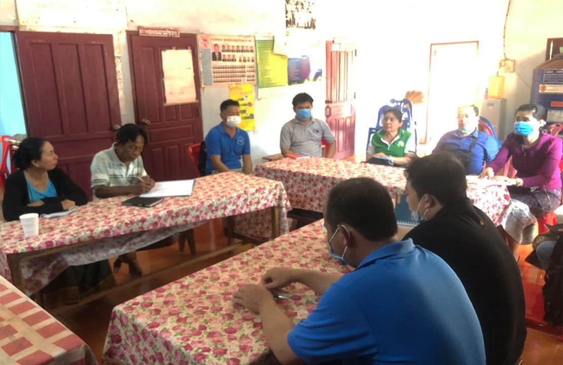
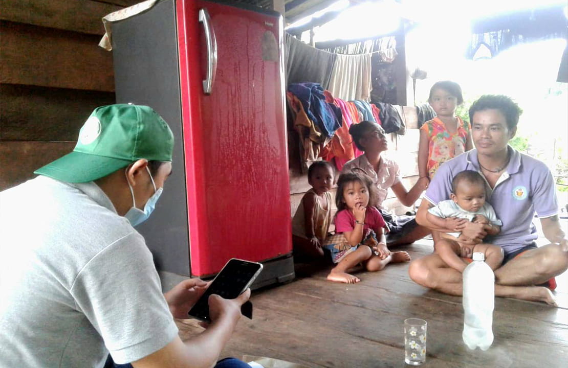
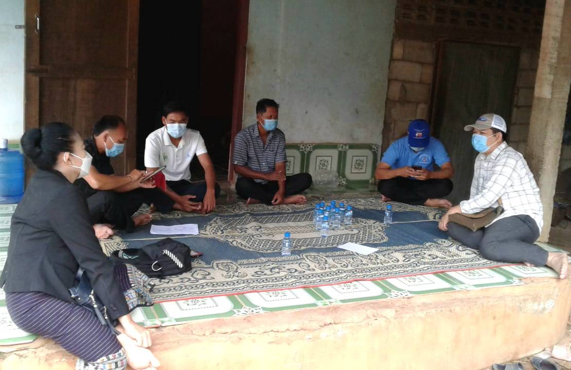
Khammouane Province is a province in the center of Laos. It
is a very suitable province for this pilot survey of the
“Project for Supporting Agricultural Survey on Promoting
Sustainable Agriculture because Khammouane Province is
consists of various agricultural productions such as crops,
livestock, fishery, aquaculture, non-timber forestry
products, and forest. Especially,it is cover all lowland,
hill, and upland area. It is a priority province of
agriculture and forestry development plan of the Ministry of
Agriculture and Forestry of Laos for commodity production,
and food security. Khammouane Province covers an area of
16,315 square kilometers and is mostly of forested
mountainous terrain. Many streams flow through the province
to join the Mekong River. The vast forests of the Nakai-Nam
Theun National Park are an important watershed that feeds
many Mekong tributaries as well as form the catchment area
for Nam Theun 2, the largest hydropower project in Laos. The
population of the province according to the 2015 Population
census is 392,052.
AFSIS Secretariat has been providing time series data by Database, as well as reports on supply and demand information and production forecasts for five main crops. These reports are known as the Agricultural Commodity Outlook (ACO) and Early Warning Information (EWI). Initially, the activities focused only rice-related data, but over time, the scope expanded to include all five major crops in alignment with the AFSIS database. Under the implementation of the SAFER project, the AFSIS Focal Points had discussed on the appropriate agricultural commodity to be added as a new target commodity apart from five main crops. Following deliberations, the meeting concluded that “Laying Hens” would be the new commodity added to the AFSIS Database, as well as the ACO and EWI reports. The AFSIS Secretariat developed a guidebook outlines the data collection process and provides clear definitions and descriptions of the necessary data items to support the integration of this new commodity into AFSIS’s reporting mechanisms.
Sub-indicator 1:
Farm output value per hectare
Sub-indicator 2:
Net farm income
Sub-indicator 3:
Risk mitigation mechanisms
Sub-indicator 4:
Prevalence of soil degradation
Sub-indicator 5:
Variation in water availability

Sub-indicator 6:
Management of fertilizers

Sub-indicator 7:
Management of pesticides

Sub-indicator 8:
Use of biodiversity-supportive practices

Sub-indicator 9:
Wage rate in agriculture
Sub-indicator 10:
Food insecurity experience scale (FIES)
Sub-indicator 11:
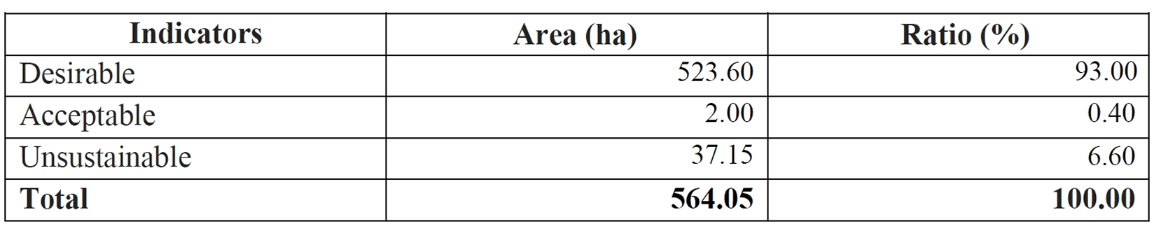
Secure tenure rights to land
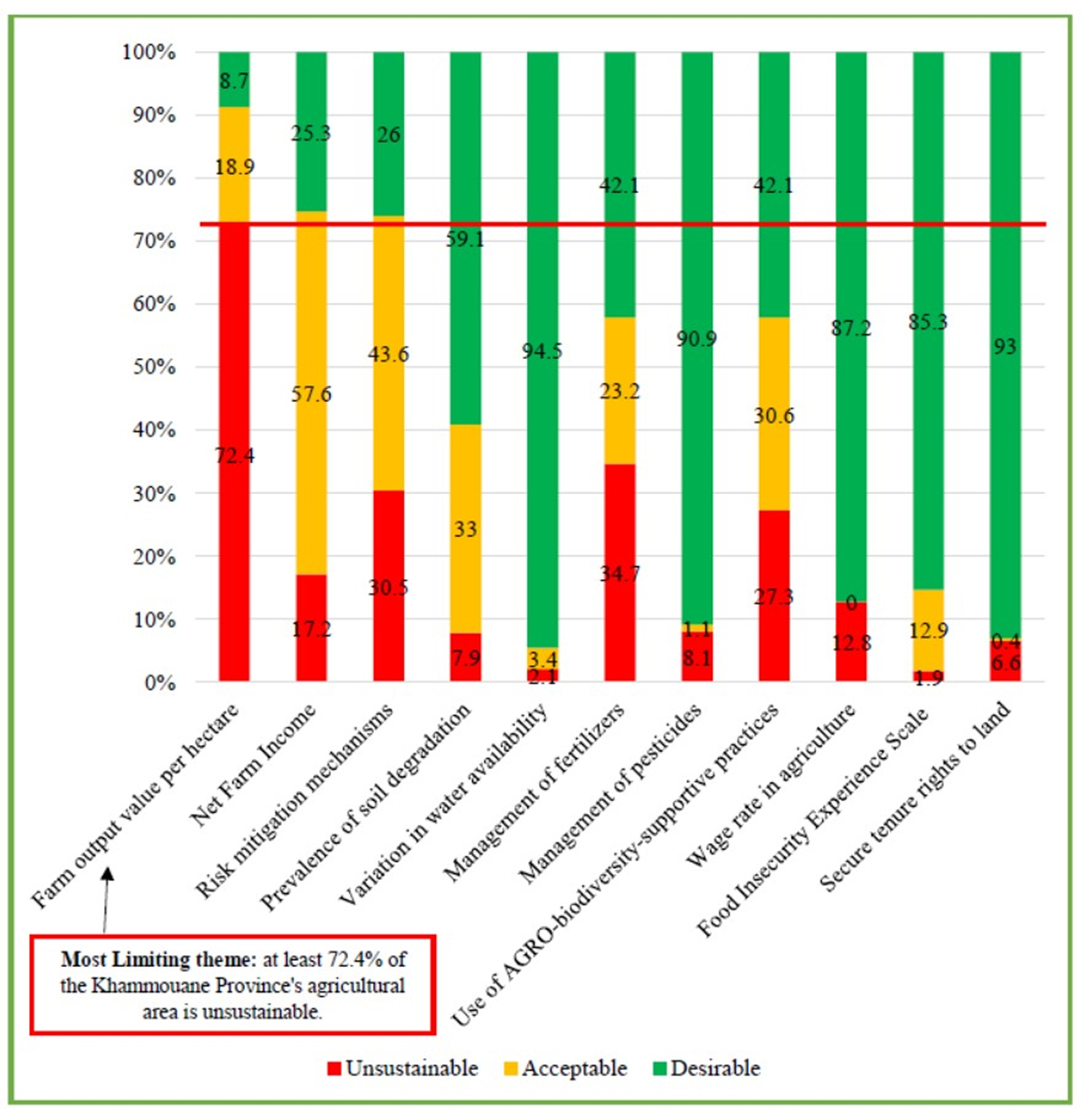
SDG 2.4.1 Dashboard
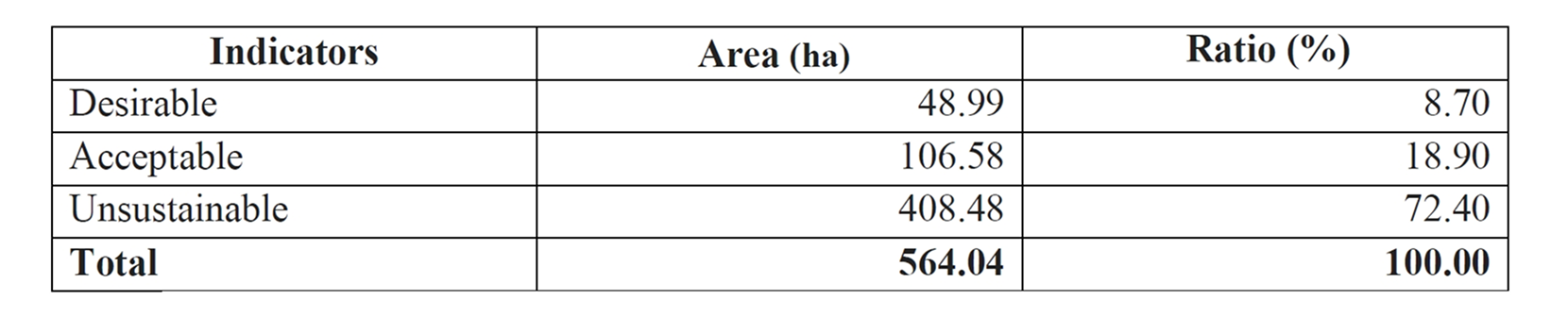
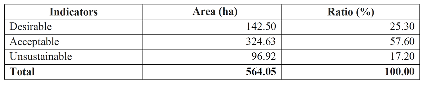
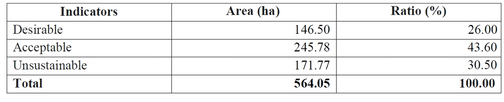
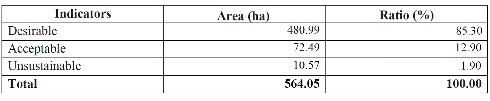
The result from the survey in Khammouane Province shown that there is only Sub-indicator 1: Farm output value per hectare have high percentage of unsustainable 72.4% that in line with all most farm households cultivated rice around 204 of 218 households, but the yield is quite low, the average yield is 2.18 tones/hectares and the price of paddy rice is also low, the average is 3,284 kip/kg which effect to Sub-indicator 2: Net farm Income, have 57.6% of Acceptable.
- The government should find ways to increase crop and
livestock productivities of farmers by introducing new
technologies including state-of-the-art equipment and
machinery. - The government should support and promote farmers in
establishing farmer associations or agricultural
cooperatives to have more strong bargaining power
especially for smallholder farmers. Moreover the
government should organize the training program for the
farmers on how to apply improved crop varieties and use
chemical fertilizer on crop cultivation in an
appropriate way to achieve higher productivity. - The government should pay more attention in extending
services and improving technology in farming as both
factors in agricultural sector are still practiced in a
small scale which leads to low production. - It would be better if the survey period match with
the crop growth stage of Lao PDR because it is very
complicated and confusing for respondents and difficult
to obtain accurate data when asking farmers and
crop-producing companies about their production and
value. Furthermore, some definitions such as type of
pesticide, chemical fertilizer...etc were not familiar
to Lao people and it was difficult for the enumerators
and respondents to understand. Thus, if the questions
are adjusted to the contexts of Laos, the answers will
be smoother and more accurate. - There are difficulties in merging all data into one
file as some data were exported from CAPI in separated
files. In the future, this problem might have been
solved by keying zero (0) in the CAPI in case some
question is not applicable (N/A) instead of leaving it
blank or use another software for data analysis such as
STATA, Eview, R software which CAPI can export roster
question data easily. - The government and other donors should continuously
be supporting agricultural surveys in the whole country
of Laos on SDG indicator 2.4.1 to know the status of
sustainable agriculture in Laos, and also promote and
improve sustainable agriculture in the future.
This output focuses on strengthening the capacity of
officers from ASEAN Member Countries, in collaboration with
JAXA and RESTEC, to develop the necessary skills to operate
the INAHOR system using satellite imagery (ALOS-2 data) for
estimating rice cultivation areas in target regions. Upon
completion of the training, participants are expected to be
able to prepare training data for INAHOR, estimate rice
cultivation areas in their respective countries, and
generate corresponding maps using the software. Furthermore,
they will be equipped with the knowledge and capability to
adopt and integrate satellite-based technologies into
agricultural statistics within their national statistical
systems. The AFSIS Secretariat conducted both regional
workshops for member countries and in-countries activity in
Lao PDR, Cambodia in 2023, Thailand and Vietnam in 2024, and
Indonesia and Myanmar in 2025, respectively.
SAS-PSA Project in Lao PDR A pilot study on SDG indicator 2.4.1 in Khammouane Province, Lao PDR
Download PDF